
By Robert Tunstead, Natural Resources Conservation Service (NRCS)
“Blue carbon” is the term used to describe the carbon captured by the world’s oceans and coastal ecosystems. Salt marshes take up large amounts of carbon dioxide during the summer growing season and store it in the form of organic matter. This process of capturing and storing, or sequestering, carbon occurs at a much faster rate in salt marshes and other highly productive coastal ecosystems than in upland forests. Left undisturbed, salt marshes provide an important natural way of reducing the impact of greenhouse gases on our planet.
How much blue carbon is captured and stored in coastal soils? The National Coastal Blue Carbon Assessment project is an initiative started by the Natural Resources Conservation Service (NRCS) Soil and Plant Science Division’s Coastal Zone Soil Survey Focus Team to help answer this question by measuring blue carbon throughout the country. Here in New Jersey, the NRCS’s Hammonton Soil Survey Office is partnering with the Barnegat Bay Partnership (BBP) to provide soils data as part of an EPA Regional Applied Research Effort (RARE) grant project. The main goal of the project is to study coastal wetland marsh degradation within the Barnegat Bay estuary. However, along with providing typical soil sampling for the project, the Hammonton Soil Survey Office is also collecting soil samples for blue carbon analysis.

After a delay due to COVID-19 stay-at-home orders, field sampling for the project began in June, with researchers using proper social distancing and proper PPE equipment. At the 25 sampling sites, the BBP is conducting habitat and biological studies, while the NRCS is collecting soil samples. The NRCS retrieves three vibracores at each site location. Vibracoring is a sediment sampling methodology used to retrieve a continuous, undisturbed sample of unconsolidated saturated sediments.
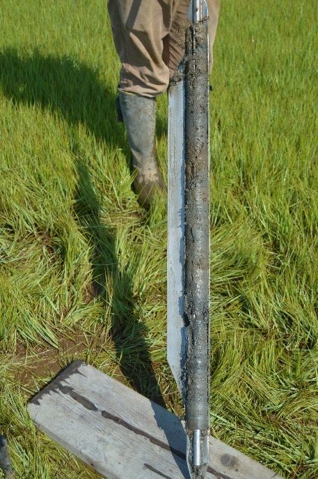
Two vibracores are examined in the field, then sent to a local lab where they are split open, photographed, described, and sampled by soil scientists from the Hammonton Soil Survey Office. After this initial sampling work, they are sent to the NRCS’s Kellogg Soil Survey Lab for a complete soil analysis. The third vibracore is sent to a separate team at the National Soil Survey Center for “whole core” blue carbon analysis.
Thanks to this joint collaborative effort by the BBP and NRCS, soils data is contributing to two important research projects – the BBP’s study of the degradation of coastal tidal wetlands in the Barnegat Bay estuary and the NRCS’s study of the amount of blue carbon stored within this valuable coastal ecosystem. The results of this project will help inform local partners in their efforts to protect and restore the deteriorating but critical tidal wetlands in our watershed.
